Project
Technical Assistance - Improving Resilience and Safety of the Local Road Transport Network in the Republic of Serbia.
|
|
|
|
|
|
Technical Assistance - Improving Resilience and Safety of the Local Road Transport Network in the Republic of Serbia.
A resilient road transport infrastructure network can withstand disturbances and recover its original performance level quickly
|
| Project Contexts |
World Bank helps Serbia and wider West Balkan strengthen road resilience to climate risks.
These efforts include:
- Methodology developed to assess natural hazard vulnerability.
- Action plan created for climate-resilient road asset management.
60% of local roads found more vulnerable to past disasters, requiring tailored approaches.
The Project aims to increase the ability of the local road transport network to cope with natural hazards and improve the delivery of services.
| Project Goals |
- Establish a framework for improving the resilience of the local roads network against natural hazards.
- Enhancing the resilience of the road transport network and service delivery.
To achieve this, a new user-friendly tool is introduced that is simple enough for local level authorities and their technical staff to use.
| Project Task |
Task 1: Developing Methodology for assessing local roads transport network resilience and safety.
Task 2: Developing local roads transport network Diagnostic Tools and Practical Guidelines.
Task 3: Local Transport Network Resilience and Investment needs Assessment in Pilot LSGs.
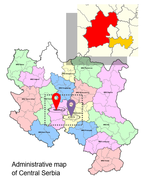
| Project Area |
Two pilot areas have been chosen to assess the feasibility of implementing the Methodology developed in different types of local communities:
 Aleksandrovac Municipality, a less developed area with a population of 23,551 and a local road network of 407.4km
 City of Kraljevo, a more developed area with a population of 111,491 and a local road network of 326.2km.
|
Improving resilience relies on the ability to evaluate and understand the direct and indirect impact of the relevant transport hazards affecting infrastructure
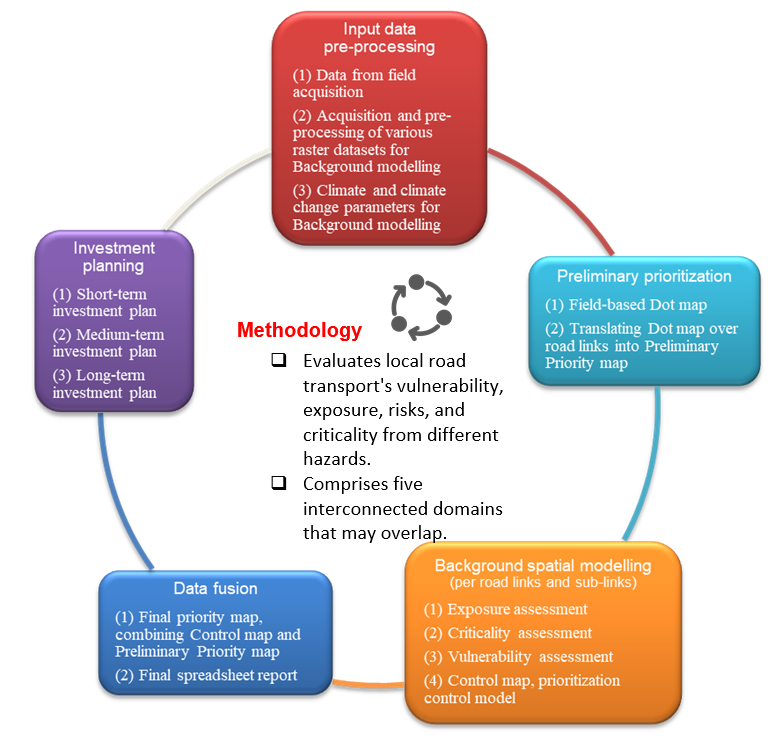
| Methodology |
The Methodology evaluates how vulnerable and exposed the local road transport network is to certain hazards, as well as the level of risk and criticality posed by these hazards.
|
It is divided into five interconnected domains that can overlap or combine:
-
Input data pre-processing
- Input data 1, data from field acquisition
- Input data 2, acquisition and pre-processing of various raster datasets, such as terrain model, geological, soil, environmental and other thematic maps needed for Background modelling
- Input data 3, climate and climate change parameters in raster format, for baseline, medium ~2050, and long-term ~2100 projections needed for Background modelling
-
Preliminary prioritization
- Automatization 1, field-based Dot map
- Automatization 2, translating Dot map over road links into Preliminary Priority map
-
Background spatial modelling
- Background 1 – Exposure assessment, per road links and sub-links
- Background 2 – Criticality assessment, per road links and sub-links
- Background 3 – Vulnerability assessment, per road links and sub-links
- Background 4 - Control map, prioritization control modelg
-
Data fusion
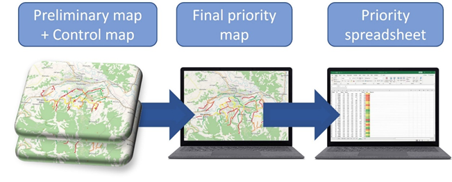
- Final priority map, combining Control map and Preliminary Priority map
- Final spreadsheet report, per link
-
Investment planning
- Short-term investment plan
- Medium-term investment plan
- Long-term investment plan
|
| Practical Guidelines |
The Practical Guidelines provides a comprehensive framework for assessing exposure, vulnerability, risk, and criticality of local transport networks.
The guidelines are designed to be used in conjunction with the Methodology, which provides a detailed explanation of the underlying concepts and procedures.
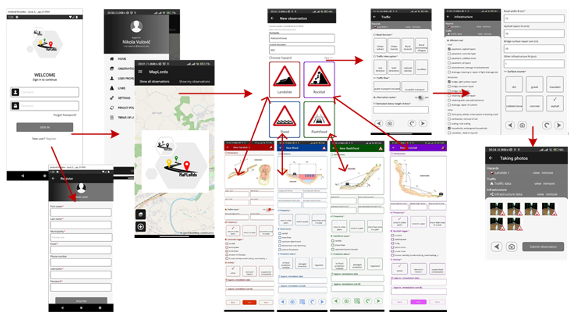
To facilitate the implementation of the Practical Guidelines, the MaPLoRds software system has been developed, including a set of tools specifically designed for this purpose.
These tools are designed to be user-friendly and intuitive and are intended to help local-level authorities and technical staff navigate the complexities of the assessment process.
![]() Local communities can:
Local communities can:
- Gain a better understanding of the risks and vulnerabilities of their transport networks and
- Take steps to address these issues in a proactive and effective manner

The Project explores how policy makers at the Local-Self Government (LSG) level can prioritize and interact when making investments in road transport infrastructure that impact the daily lives and businesses of local communities.
| Investment planning |
Investment plans for local roads play a crucial role in the socio-economic development of local communities.
It serves as a crucial link between a municipality or city's strategic vision, their land use and maintenance plans, and their annual budgets.
Investment planning is among the four main components that make up the development of road investment:
The LSGs spends considerable budget portions on local road developments but mostly in the absence of thorough and systematic methodology.
Investment plans will feature a comprehensive list of prioritized projects from the Priority Spreadsheet that can be financed using the current available funds, along with any other strategic goals and outcomes aligned with the Local-Self Government's requirements.
Vision and long-term strategy for local road network, covering state transit roads
Funding available to spend on the local road network during the lifetime of the road investment strategy
Plan outlining the path how allocated fund will be spent to deliver expected outcomes by the LSG
Metrics and KPIs to monitor specific expectation of the local road network manager and the future road local network
What is MapLords?
MaPLoRds is a software system developed to enable users to assess the climate resilience of their local road network.
It is an essential tool for applying a methodology developed to enhance the climate resilience of the local road network.
The system analyzes the characteristics of the road network, climate hazards, and vulnerability to evaluate the network's climate resilience.
MaPLoRds features user-friendly interfaces and visualization tools to support the decision-making process.
The MaPLoRds system consists of both a mobile and a web application.

The system uses open data from Geographic Information Systems (GIS) and open maps. This data is available for use both in the field, using mobile devices, and in the office, using a web application.
The mobile and web application is primarily in Serbian, but also includes English. However, the app can support other languages too. All the different languages are stored in a central place and can be easily added to the app when needed.
The app includes a list of important words and phrases in both Serbian and English, which is useful for understanding the app's interface.